Food Truck Radar project consists of a user interface and a web service, where users can query the food trucks in the San Francisco by their status or location. The results are shown with markers on a Google Map.
The whole project is deployed to Heroku, therefore you can check and play around with the service by clicking here.
Developers can clone or download the project for examining the source code. In order to run the project in your local machine, you can apply the following steps:
Before continuing, please be sure that the following installations are ready:
- JDK 1.8 (or above)
- Maven 3.5.0
- Git 2.8.1 (or above)
For Windows operating systems, open a command shell and direct to the root folder of the project. Please check that pom.xml file is in the directory. Execute the following commands for cleaning, compiling and packaging:
mvn clean compile
mvn package
You should see a .jar file in the target directory. This .jar file includes an embedded Tomcat. Run this file with the following command:
java -jar gs-rest-service-0.1.0.jar
A Spring Boot application with an embedded Tomcat server should be started. You can try sending GET requests to check if the web server is up and running. I have used a Chrome extension name Postman during my tests. Sample API URIs are available below in the API section.
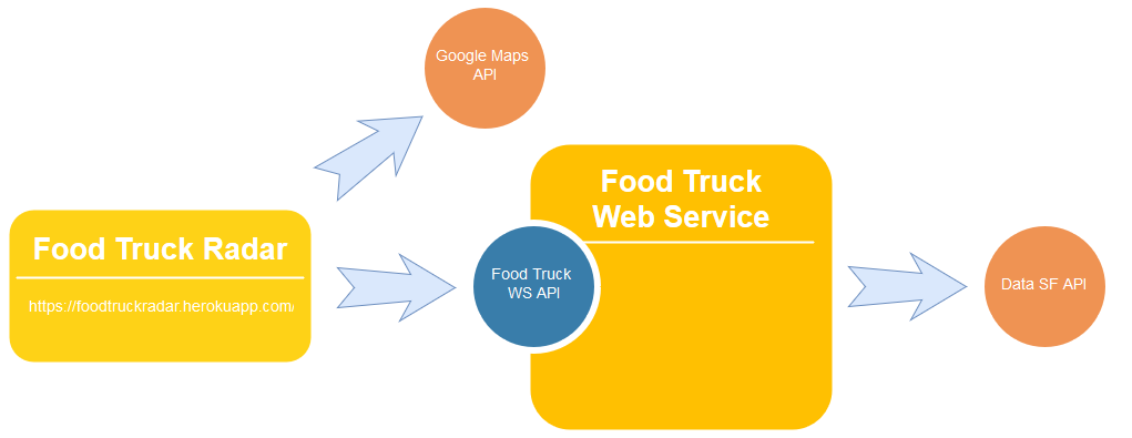
Food Truck Radar is a full-stack project that consists of a front-end and a back-end component. Front-end is a simple index.html file that accepts the user inputs, calls the API provided by the back-end and shows the results on Google Maps by using the Google Maps API. Back-end is a Java web service that provides a REST API, accepts queries with REST URIs, connects to DataSF by calling the DataSF API and indexes the received JSON objects.
User interface is a single html file. User input validations, Google Maps API callings and GET requests to the server side are handled inside the embedded javascript block.
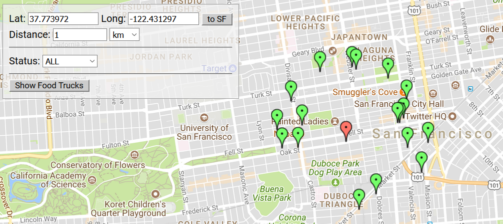
If user clicks to Show Food Trucks without specifying any query inputs, then all the available food tracks are shown with a green marker on the map. A user can specify the status of food truck and / or specify a circle by entering latitude and longitude of the center of the circle and the radius of the circle. Food trucks that have the given status and / or reside in the given circle are shown on the map.
Google Maps API provides a huge set of abilities and a very good documentation for front-end developers. It was the first I use the API, end it was a quite easy to implement the API calls thanks to the documentation.
Back-end is basically a Spring Boot application - a Java web application that resolves the maven dependencies automatically and uses an embedded Tomcat server. System overview is shown below:

Rest Controller class is a servlet class that accepts GET requests and forwards the user inputs to the Query Handler. Query Handler class uses the Geodesic Distance Calculator for querying food trucks inside a specific circle. Client class calls the Data SF API, converts the received JSON string to a list of Food Truck objects and pushes the object to the Accessor. Accessor class can be interpreted as a database stub. It allows CRUD operations and maintains a map for storing all food trucks and another map for indexing the food trucks by their status. Accessor, Query Handler, Geodesic Calculator and Client classes are singleton, since we only need one instance of them in the virtual machine.
Spring Boot allows you to create standalone Spring applications and embed Tomcat without any code generation.It provides a strong framework and handles pretty much most of the dirty works (especially, embedding a web server is a challenging configuration task). Like Google Maps API, I have no experience with Spring Boot.
On the other hand, I have six years of experience in Java and frequently used maps (especially HashMap) and singleton pattern in a lot of projects before. For indexing and storing a data where each item has one or more key values, hash maps provide a fast and effective solution. Indexing on status field also accelerates the query results. For each state, we maintain a list of food trucks, and these lists are constructed and populated only during initialization phase. Therefore, when a query on status is received, we do not traverse through the all of the food trucks. The complexity is still O(n) since we are converting a list of objects to a JSON string, but in practice, it saves a lot of time.
A client class can obtain all the food trucks in the system by using the following URI:
https://foodtruckradar.herokuapp.com/food-trucks/
For querying food trucks by their status following URI is used:
https://foodtruckradar.herokuapp.com/food-trucks/query?status={status}

Example:
https://foodtruckradar.herokuapp.com/food-trucks/query?status=REQUESTED
For querying food trucks that reside in a specific circle, following URI is used:
https://foodtruckradar.herokuapp.com/food-trucks/query?latitude={latitude}&longitude={longitude}&radius={radius}&radius_unit={radius_unit}

Example:
https://foodtruckradar.herokuapp.com/food-trucks/query?latitude=37.770443352285376&longitude=-122.36778259277344&radius=2&radius_unit=km
The queries mentioned above can also combined together like this:
https://foodtruckradar.herokuapp.com/food-trucks/query?status=REQUESTED&latitude=37.770443352285376&longitude=-122.36778259277344&radius=2&radius_unit=km
Possible future works for the projects are:
- New queries can be allowed (for example a query on working hours).
- API for food truck data of other states or countries can be researched, and if available, added to the web service.
No license is specified/required for this project.