Edited/Deleted features still in Shapefile #21355
Comments
|
Author Name: Saber Razmjooei (@saberraz) Which version of QGIS? Could you provide an example file?
|
|
Author Name: Jamie Portman (Jamie Portman) It was v2.10.1 I didn't have the file anymore - cleaned them up after resolving the issue.
|
|
Author Name: Jamie Portman (Jamie Portman) It is by no means happening all the time.... just occasionally! |
|
Author Name: Saber Razmjooei (@saberraz) Does it happen with other layers or only this one? In my experience, it usually happens to the layers with topological error. In your example, there are 2 overlapping features (id:4 and 11). Try to test with a "clean" file and report back.
|
|
Author Name: Jamie Portman (Jamie Portman) This is the only one I have noticed it with.... but then I'm not uploading all my layers into another platform such as AGOL to view! I ran "check geometry validity" and there was 1 duplicate node in an unrelated polygon. I deleted it and re-uploaded and the 'old' feature shapes are still visible in AGOL, so it has not resolved the problem. I would not consider overlapping features to necessarily be a topological error! They could be, depending on what they are representing, but there are many reasons by a shapefile (or any GIS layer) may have overlapping features or gaps. |
|
Author Name: Jamie Portman (Jamie Portman) I just performed another test... I made a copy of the troublesome Shapefile in file explorer (I did not do a save-as in QGIS as that seems to resolve the issue). I have uploaded the file edited in v2.8.
|
|
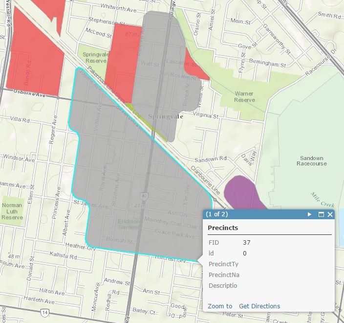
Author Name: Jamie Portman (Jamie Portman) I have made exactly the same changes in v2.10 to the original file as those I made in v2.8.2 to the copy. In QGIS it only sees 1 object in QGIS, but when I upload to AGOL (or open in ArcGIS) there are two objects there (the original and the edited one) - FID37 and FID39. The original edit was done by cutting the object out of the layer and then pasting it back in (to get it to respect the 'avoid intersection') rule. I recall some other queries/bugs relating to the 'deleted' flag.
|
|
Author Name: Saber Razmjooei (@saberraz) I say it is a regression. I will check with dev, 2.10 and 2.8. Could you also check with QGIS processing toolbox. For example my original bug, if I remove a feature and buffer it using SAGA, it will create a buffer of the deleted feature. |
|
Author Name: Saber Razmjooei (@saberraz) This affects the feature count. Deleted features still appear in feature count. |
|
Author Name: Jamie Portman (Jamie Portman) There are definitely two 'phantom' objects that remain in the table unless a save-as is done. I tried the SAGA Buffer in Processing Toolbox, however this actually results in only the first 13 features being buffered. I also tried a "Convert polygon/line vertices to points" and only the first 13 records have vertices created. I believe it may be stumbling across an issue with the 14th object and it simply stopping going any further, as I created a new feature in QGIS (a simple polygon with 4 vertices) and re-ran the buffer and vertices>points process and both results still stopped at the 13 feature... However, even after deleting the 14th and all subsequent objects except the last one just added as a test object, it still fails to buffer the new test object. (All this testing has been done on the same shapefile uploaded in my previous update.) If is provides any additional context information, many of the objects in our GIS layers are being extracted from DXF CAD files - thye appear to import through into the GIS format and copy/paste perfectly fine, but perhaps there is some underlying object issue that is somehow causing issues? We have recently had other objects that 'dissapear' when an intersect process is done - however all objects pass all the geometry validity checks... |
|
Author Name: Saber Razmjooei (@saberraz) Please see the original ticket.
|
Author Name: Jamie Portman (Jamie Portman)
Original Redmine Issue: 13297
Affected QGIS version: 2.10.1
Redmine category:digitising
Recently experienced an issue much the same as this previously closed issue (#19349) where a shapefile was edited, some features removed and others edited, saved and qgis closed.
The shapefile then loaded into ArcGIS online, and the deleted and modified polygon were visible.
When I reopened the file in qgis they look as they should. I opened the file in ArcGIS desktop and the deleted objects are still there and changes to shapes are lost.
Saving the shapefile as a copy did resolve the issue so that the file could be used in other applications.
Basically, the same behaviour as previously reported, but in the latest release version.
Related issue(s): #19592 (relates), #21242 (relates), #21471 (relates)
Redmine related issue(s): 11296, 13180, 13422
The text was updated successfully, but these errors were encountered: